|
|
|||||||||||||||||
| Point ID: 8561 | Downloads | Plots | Site Data | Code: 11099 |
|
|
|||||||||||||||||
| Download | |
|---|---|
| Site Descriptor Information | Site Time Series Data |
| Link to all available data | |
| View: | Time Series | All |
| Units: | mm |
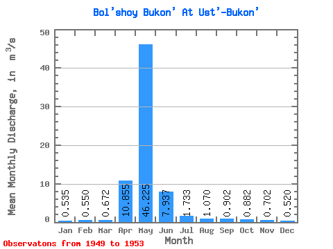
| Statistic | Jan | Feb | Mar | Apr | May | Jun | Jul | Aug | Sep | Oct | Nov | Dec | Annual |
|---|---|---|---|---|---|---|---|---|---|---|---|---|---|
| Mean | 0.54 | 0.55 | 0.67 | 10.86 | 46.23 | 7.94 | 1.73 | 1.07 | 0.90 | 0.88 | 0.70 | 0.52 | 6.04 |
| Standard Deviation | 0.17 | 0.34 | 0.38 | 13.93 | 34.71 | 5.91 | 0.77 | 0.23 | 0.18 | 0.18 | 0.06 | 0.08 | 4.41 |
| Min | 0.32 | 0.34 | 0.27 | 3.19 | 17.10 | 2.23 | 0.95 | 0.81 | 0.66 | 0.69 | 0.63 | 0.41 | 2.39 |
| Max | 0.74 | 1.05 | 1.14 | 31.70 | 93.10 | 14.20 | 2.41 | 1.29 | 1.14 | 1.13 | 0.77 | 0.64 | 11.99 |
| Coefficient of Variation | 0.32 | 0.61 | 0.57 | 1.28 | 0.75 | 0.74 | 0.45 | 0.21 | 0.20 | 0.20 | 0.09 | 0.16 | 0.73 |
 Return to R-Arctic Net Home Page