|
|
|||||||||||||||||
| Point ID: 8552 | Downloads | Plots | Site Data | Code: 11082 |
|
|
|||||||||||||||||
| Download | |
|---|---|
| Site Descriptor Information | Site Time Series Data |
| Link to all available data | |
| View: | Time Series | All |
| Units: | mm |
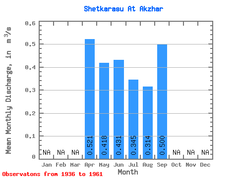
| Statistic | Jan | Feb | Mar | Apr | May | Jun | Jul | Aug | Sep | Oct | Nov | Dec | Annual |
|---|---|---|---|---|---|---|---|---|---|---|---|---|---|
| Mean | 0.52 | 0.42 | 0.43 | 0.34 | 0.31 | 0.50 | |||||||
| Standard Deviation | 0.16 | 0.16 | 0.12 | 0.16 | |||||||||
| Min | 0.52 | 0.22 | 0.18 | 0.14 | 0.13 | 0.50 | |||||||
| Max | 0.52 | 0.61 | 0.60 | 0.52 | 0.42 | 0.50 | |||||||
| Coefficient of Variation | 0.39 | 0.36 | 0.34 | 0.51 |
 Return to R-Arctic Net Home Page