|
|
|||||||||||||||||
| Point ID: 8551 | Downloads | Plots | Site Data | Code: 11081 |
|
|
|||||||||||||||||
| Download | |
|---|---|
| Site Descriptor Information | Site Time Series Data |
| Link to all available data | |
| View: | Time Series | All |
| Units: | mm |
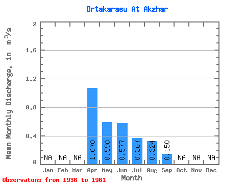
| Statistic | Jan | Feb | Mar | Apr | May | Jun | Jul | Aug | Sep | Oct | Nov | Dec | Annual |
|---|---|---|---|---|---|---|---|---|---|---|---|---|---|
| Mean | 1.07 | 0.59 | 0.58 | 0.37 | 0.32 | 0.15 | |||||||
| Standard Deviation | 0.21 | 0.22 | 0.18 | 0.30 | |||||||||
| Min | 1.07 | 0.41 | 0.18 | 0.09 | 0.13 | 0.15 | |||||||
| Max | 1.07 | 0.82 | 0.87 | 0.52 | 0.67 | 0.15 | |||||||
| Coefficient of Variation | 0.35 | 0.39 | 0.49 | 0.93 |
 Return to R-Arctic Net Home Page