|
|
|||||||||||||||||
| Point ID: 8550 | Downloads | Plots | Site Data | Code: 11080 |
|
|
|||||||||||||||||
| Download | |
|---|---|
| Site Descriptor Information | Site Time Series Data |
| Link to all available data | |
| View: | Time Series | All |
| Units: | mm |
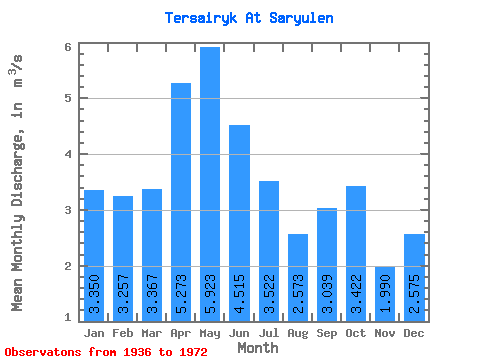
| Statistic | Jan | Feb | Mar | Apr | May | Jun | Jul | Aug | Sep | Oct | Nov | Dec | Annual |
|---|---|---|---|---|---|---|---|---|---|---|---|---|---|
| Mean | 3.35 | 3.26 | 3.37 | 5.27 | 5.92 | 4.51 | 3.52 | 2.57 | 3.04 | 3.42 | 1.99 | 2.58 | 3.97 |
| Standard Deviation | 1.85 | 2.57 | 1.83 | 1.73 | 3.69 | 2.81 | 3.05 | 2.47 | 3.22 | 3.82 | 0.27 | 0.19 | |
| Min | 1.92 | 1.44 | 1.90 | 2.92 | 1.10 | 1.21 | 0.57 | 0.46 | 0.40 | 1.10 | 1.80 | 2.44 | 3.97 |
| Max | 5.44 | 6.20 | 5.42 | 7.07 | 12.50 | 13.50 | 13.80 | 9.74 | 11.10 | 11.00 | 2.18 | 2.71 | 3.97 |
| Coefficient of Variation | 0.55 | 0.79 | 0.54 | 0.33 | 0.62 | 0.62 | 0.86 | 0.96 | 1.06 | 1.12 | 0.14 | 0.07 |
 Return to R-Arctic Net Home Page