|
|
|||||||||||||||||
| Point ID: 8548 | Downloads | Plots | Site Data | Code: 11076 |
|
|
|||||||||||||||||
| Download | |
|---|---|
| Site Descriptor Information | Site Time Series Data |
| Link to all available data | |
| View: | Time Series | All |
| Units: | mm |
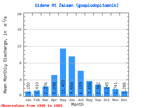
| Statistic | Jan | Feb | Mar | Apr | May | Jun | Jul | Aug | Sep | Oct | Nov | Dec | Annual |
|---|---|---|---|---|---|---|---|---|---|---|---|---|---|
| Mean | 1.15 | 1.41 | 2.38 | 5.10 | 11.45 | 9.55 | 6.16 | 3.66 | 2.86 | 2.25 | 1.74 | 1.29 | |
| Standard Deviation | 0.11 | 0.31 | 0.29 | 3.95 | 4.38 | 4.31 | 3.02 | 1.94 | 1.87 | 1.22 | 0.42 | 0.63 | |
| Min | 1.07 | 1.05 | 2.17 | 1.61 | 5.92 | 3.92 | 1.93 | 1.56 | 1.30 | 1.12 | 1.35 | 0.84 | |
| Max | 1.23 | 1.60 | 2.58 | 10.70 | 20.70 | 18.30 | 12.40 | 8.91 | 6.80 | 4.50 | 2.19 | 1.73 | |
| Coefficient of Variation | 0.10 | 0.22 | 0.12 | 0.77 | 0.38 | 0.45 | 0.49 | 0.53 | 0.65 | 0.54 | 0.24 | 0.49 |
 Return to R-Arctic Net Home Page