|
|
|||||||||||||||||
| Point ID: 8530 | Downloads | Plots | Site Data | Code: 10614 |
|
|
|||||||||||||||||
| Download | |
|---|---|
| Site Descriptor Information | Site Time Series Data |
| Link to all available data | |
| View: | Time Series | All |
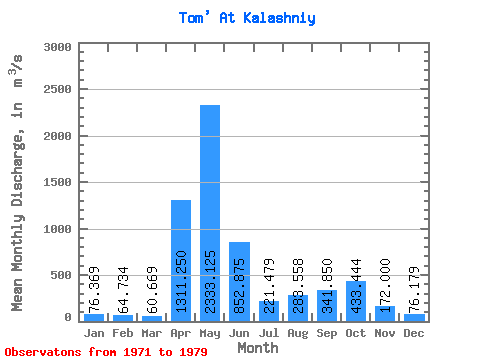
| Units: | mm |
| Statistic | Jan | Feb | Mar | Apr | May | Jun | Jul | Aug | Sep | Oct | Nov | Dec | Annual |
|---|---|---|---|---|---|---|---|---|---|---|---|---|---|
| Mean | 76.37 | 64.73 | 60.67 | 1311.25 | 2333.12 | 852.88 | 221.48 | 283.56 | 341.85 | 433.44 | 172.00 | 76.18 | 525.99 |
| Standard Deviation | 81.83 | 69.80 | 65.09 | 929.40 | 2279.75 | 895.45 | 206.57 | 308.43 | 370.31 | 516.85 | 222.41 | 90.93 | 462.11 |
| Min | 0.45 | 0.30 | 0.26 | 350.00 | 95.00 | 12.00 | 0.93 | 0.76 | 1.90 | 2.40 | 1.30 | 0.49 | 90.01 |
| Max | 169.00 | 145.00 | 143.00 | 2940.00 | 6020.00 | 2200.00 | 500.00 | 784.00 | 902.00 | 1410.00 | 610.00 | 211.00 | 1124.92 |
| Coefficient of Variation | 1.07 | 1.08 | 1.07 | 0.71 | 0.98 | 1.05 | 0.93 | 1.09 | 1.08 | 1.19 | 1.29 | 1.19 | 0.88 |
 Return to R-Arctic Net Home Page