|
|
|||||||||||||||||
| Point ID: 8526 | Downloads | Plots | Site Data | Code: 10606 |
|
|
|||||||||||||||||
| Download | |
|---|---|
| Site Descriptor Information | Site Time Series Data |
| Link to all available data | |
| View: | Time Series | All |
| Units: | mm |
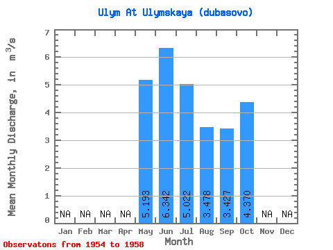
| Statistic | Jan | Feb | Mar | Apr | May | Jun | Jul | Aug | Sep | Oct | Nov | Dec | Annual |
|---|---|---|---|---|---|---|---|---|---|---|---|---|---|
| Mean | 5.19 | 6.34 | 5.02 | 3.48 | 3.43 | 4.37 | |||||||
| Standard Deviation | 2.13 | 3.41 | 3.55 | 2.62 | 1.90 | 2.50 | |||||||
| Min | 2.78 | 3.86 | 1.87 | 1.29 | 1.63 | 2.03 | |||||||
| Max | 6.80 | 11.60 | 10.50 | 7.74 | 6.02 | 7.00 | |||||||
| Coefficient of Variation | 0.41 | 0.54 | 0.71 | 0.76 | 0.55 | 0.57 |
 Return to R-Arctic Net Home Page