|
|
|||||||||||||||||
| Point ID: 8515 | Downloads | Plots | Site Data | Code: 10528 |
|
|
|||||||||||||||||
| Download | |
|---|---|
| Site Descriptor Information | Site Time Series Data |
| Link to all available data | |
| View: | Time Series | All |
| Units: | mm |
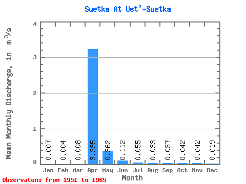
| Statistic | Jan | Feb | Mar | Apr | May | Jun | Jul | Aug | Sep | Oct | Nov | Dec | Annual |
|---|---|---|---|---|---|---|---|---|---|---|---|---|---|
| Mean | 0.01 | 0.00 | 0.01 | 3.23 | 0.36 | 0.11 | 0.06 | 0.03 | 0.04 | 0.04 | 0.04 | 0.02 | 0.33 |
| Standard Deviation | 0.01 | 0.01 | 0.02 | 2.62 | 0.27 | 0.12 | 0.05 | 0.02 | 0.03 | 0.03 | 0.03 | 0.01 | 0.24 |
| Min | 0.00 | 0.00 | 0.00 | 0.44 | 0.06 | 0.03 | 0.02 | 0.01 | 0.01 | 0.01 | 0.01 | 0.00 | 0.06 |
| Max | 0.02 | 0.02 | 0.06 | 7.94 | 0.95 | 0.45 | 0.18 | 0.09 | 0.09 | 0.09 | 0.08 | 0.05 | 0.75 |
| Coefficient of Variation | 0.95 | 1.34 | 1.91 | 0.81 | 0.74 | 1.03 | 0.86 | 0.67 | 0.74 | 0.60 | 0.62 | 0.77 | 0.73 |
 Return to R-Arctic Net Home Page