|
|
|||||||||||||||||
| Point ID: 8502 | Downloads | Plots | Site Data | Code: 10446 |
|
|
|||||||||||||||||
| Download | |
|---|---|
| Site Descriptor Information | Site Time Series Data |
| Link to all available data | |
| View: | Time Series | All |
| Units: | mm |
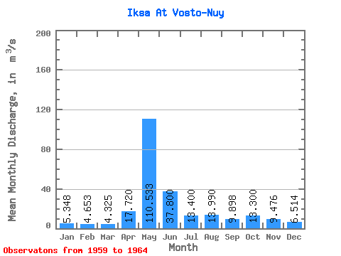
| Statistic | Jan | Feb | Mar | Apr | May | Jun | Jul | Aug | Sep | Oct | Nov | Dec | Annual |
|---|---|---|---|---|---|---|---|---|---|---|---|---|---|
| Mean | 5.35 | 4.65 | 4.33 | 17.72 | 110.53 | 37.80 | 13.40 | 13.99 | 9.90 | 13.30 | 9.48 | 6.51 | 20.57 |
| Standard Deviation | 1.01 | 0.51 | 0.55 | 18.57 | 39.12 | 25.80 | 9.93 | 12.33 | 5.95 | 9.29 | 4.45 | 1.95 | 8.51 |
| Min | 3.71 | 3.84 | 3.81 | 4.74 | 61.10 | 18.30 | 4.71 | 4.33 | 4.50 | 4.89 | 4.48 | 4.28 | 11.94 |
| Max | 6.57 | 5.23 | 5.37 | 53.90 | 169.00 | 88.30 | 29.80 | 28.70 | 19.30 | 28.80 | 16.20 | 8.95 | 32.40 |
| Coefficient of Variation | 0.19 | 0.11 | 0.13 | 1.05 | 0.35 | 0.68 | 0.74 | 0.88 | 0.60 | 0.70 | 0.47 | 0.30 | 0.41 |
 Return to R-Arctic Net Home Page