|
|
|||||||||||||||||
| Point ID: 8501 | Downloads | Plots | Site Data | Code: 10443 |
|
|
|||||||||||||||||
| Download | |
|---|---|
| Site Descriptor Information | Site Time Series Data |
| Link to all available data | |
| View: | Time Series | All |
| Units: | mm |
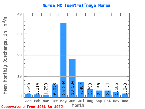
| Statistic | Jan | Feb | Mar | Apr | May | Jun | Jul | Aug | Sep | Oct | Nov | Dec | Annual |
|---|---|---|---|---|---|---|---|---|---|---|---|---|---|
| Mean | 1.55 | 1.31 | 1.25 | 6.08 | 35.38 | 18.23 | 7.41 | 3.79 | 3.20 | 3.17 | 2.69 | 1.84 | 7.18 |
| Standard Deviation | 0.53 | 0.37 | 0.32 | 6.07 | 17.83 | 13.82 | 11.18 | 2.37 | 1.27 | 1.29 | 1.29 | 0.73 | 3.44 |
| Min | 0.98 | 0.71 | 0.84 | 1.37 | 6.17 | 3.82 | 1.37 | 1.55 | 1.63 | 1.55 | 1.32 | 1.08 | 2.55 |
| Max | 3.00 | 2.21 | 1.97 | 22.60 | 68.00 | 52.80 | 45.90 | 10.40 | 5.27 | 5.99 | 5.84 | 3.94 | 13.52 |
| Coefficient of Variation | 0.34 | 0.28 | 0.25 | 1.00 | 0.50 | 0.76 | 1.51 | 0.63 | 0.40 | 0.41 | 0.48 | 0.40 | 0.48 |
 Return to R-Arctic Net Home Page