|
|
|||||||||||||||||
| Point ID: 8499 | Downloads | Plots | Site Data | Code: 10417 |
|
|
|||||||||||||||||
| Download | |
|---|---|
| Site Descriptor Information | Site Time Series Data |
| Link to all available data | |
| View: | Time Series | All |
| Units: | mm |
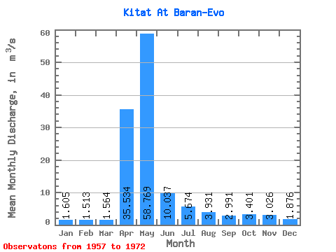
| Statistic | Jan | Feb | Mar | Apr | May | Jun | Jul | Aug | Sep | Oct | Nov | Dec | Annual |
|---|---|---|---|---|---|---|---|---|---|---|---|---|---|
| Mean | 1.60 | 1.51 | 1.56 | 35.53 | 58.77 | 10.04 | 5.67 | 3.93 | 2.99 | 3.40 | 3.03 | 1.88 | 10.66 |
| Standard Deviation | 0.44 | 0.35 | 0.40 | 21.92 | 34.31 | 6.14 | 6.08 | 2.88 | 1.01 | 1.41 | 1.33 | 0.60 | 2.85 |
| Min | 1.15 | 1.12 | 1.04 | 4.50 | 14.50 | 3.90 | 1.26 | 1.72 | 1.61 | 1.83 | 1.58 | 1.29 | 5.61 |
| Max | 2.65 | 2.15 | 2.56 | 81.50 | 114.00 | 25.70 | 26.90 | 13.20 | 4.75 | 6.34 | 6.11 | 3.67 | 14.57 |
| Coefficient of Variation | 0.27 | 0.23 | 0.26 | 0.62 | 0.58 | 0.61 | 1.07 | 0.73 | 0.34 | 0.41 | 0.44 | 0.32 | 0.27 |
 Return to R-Arctic Net Home Page