|
|
|||||||||||||||||
| Point ID: 8493 | Downloads | Plots | Site Data | Code: 10401 |
|
|
|||||||||||||||||
| Download | |
|---|---|
| Site Descriptor Information | Site Time Series Data |
| Link to all available data | |
| View: | Time Series | All |
| Units: | mm |
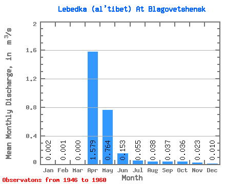
| Statistic | Jan | Feb | Mar | Apr | May | Jun | Jul | Aug | Sep | Oct | Nov | Dec | Annual |
|---|---|---|---|---|---|---|---|---|---|---|---|---|---|
| Mean | 0.00 | 0.00 | 0.00 | 1.58 | 0.76 | 0.15 | 0.06 | 0.04 | 0.04 | 0.04 | 0.02 | 0.01 | 0.23 |
| Standard Deviation | 0.01 | 0.00 | 0.00 | 1.56 | 0.85 | 0.22 | 0.06 | 0.04 | 0.03 | 0.03 | 0.02 | 0.01 | 0.14 |
| Min | 0.00 | 0.00 | 0.00 | 0.32 | 0.03 | 0.01 | 0.01 | 0.01 | 0.01 | 0.01 | 0.01 | 0.00 | 0.07 |
| Max | 0.02 | 0.01 | 0.00 | 6.00 | 3.23 | 0.77 | 0.16 | 0.13 | 0.12 | 0.11 | 0.06 | 0.04 | 0.54 |
| Coefficient of Variation | 2.93 | 3.87 | 0.99 | 1.12 | 1.42 | 1.04 | 0.95 | 0.80 | 0.80 | 0.81 | 1.35 | 0.64 |
 Return to R-Arctic Net Home Page