|
|
|||||||||||||||||
| Point ID: 8459 | Downloads | Plots | Site Data | Code: 10226 |
|
|
|||||||||||||||||
| Download | |
|---|---|
| Site Descriptor Information | Site Time Series Data |
| Link to all available data | |
| View: | Time Series | All |
| Units: | mm |
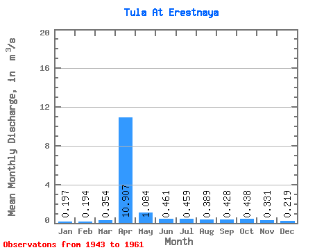
| Statistic | Jan | Feb | Mar | Apr | May | Jun | Jul | Aug | Sep | Oct | Nov | Dec | Annual |
|---|---|---|---|---|---|---|---|---|---|---|---|---|---|
| Mean | 0.20 | 0.19 | 0.35 | 10.91 | 1.08 | 0.46 | 0.46 | 0.39 | 0.43 | 0.44 | 0.33 | 0.22 | 1.29 |
| Standard Deviation | 0.09 | 0.08 | 0.44 | 7.48 | 0.79 | 0.54 | 0.59 | 0.45 | 0.48 | 0.63 | 0.26 | 0.09 | 0.69 |
| Min | 0.10 | 0.06 | 0.06 | 1.70 | 0.44 | 0.15 | 0.17 | 0.19 | 0.16 | 0.19 | 0.12 | 0.11 | 0.36 |
| Max | 0.42 | 0.35 | 1.63 | 33.30 | 3.18 | 2.48 | 2.69 | 2.15 | 2.27 | 3.00 | 1.33 | 0.45 | 3.34 |
| Coefficient of Variation | 0.47 | 0.43 | 1.23 | 0.69 | 0.73 | 1.17 | 1.29 | 1.16 | 1.12 | 1.44 | 0.78 | 0.41 | 0.54 |
 Return to R-Arctic Net Home Page