|
|
|||||||||||||||||
| Point ID: 8456 | Downloads | Plots | Site Data | Code: 10207 |
|
|
|||||||||||||||||
| Download | |
|---|---|
| Site Descriptor Information | Site Time Series Data |
| Link to all available data | |
| View: | Time Series | All |
| Units: | mm |
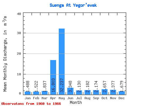
| Statistic | Jan | Feb | Mar | Apr | May | Jun | Jul | Aug | Sep | Oct | Nov | Dec | Annual |
|---|---|---|---|---|---|---|---|---|---|---|---|---|---|
| Mean | 1.49 | 1.52 | 1.84 | 16.80 | 32.24 | 3.35 | 2.13 | 2.18 | 2.17 | 2.66 | 2.38 | 1.68 | 5.54 |
| Standard Deviation | 0.22 | 0.39 | 0.88 | 12.22 | 21.59 | 1.41 | 0.74 | 0.43 | 0.66 | 0.68 | 0.89 | 0.47 | 1.31 |
| Min | 1.15 | 1.04 | 1.29 | 3.47 | 8.42 | 2.14 | 1.37 | 1.55 | 1.35 | 1.86 | 1.33 | 1.05 | 4.15 |
| Max | 1.71 | 2.22 | 3.54 | 38.10 | 62.10 | 5.56 | 3.19 | 2.74 | 3.12 | 3.65 | 3.59 | 2.48 | 7.21 |
| Coefficient of Variation | 0.14 | 0.26 | 0.48 | 0.73 | 0.67 | 0.42 | 0.35 | 0.20 | 0.30 | 0.26 | 0.38 | 0.28 | 0.24 |
 Return to R-Arctic Net Home Page