|
|
|||||||||||||||||
| Point ID: 8442 | Downloads | Plots | Site Data | Code: 10157 |
|
|
|||||||||||||||||
| Download | |
|---|---|
| Site Descriptor Information | Site Time Series Data |
| Link to all available data | |
| View: | Time Series | All |
| Units: | mm |
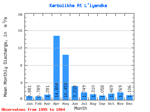
| Statistic | Jan | Feb | Mar | Apr | May | Jun | Jul | Aug | Sep | Oct | Nov | Dec | Annual |
|---|---|---|---|---|---|---|---|---|---|---|---|---|---|
| Mean | 0.88 | 0.79 | 1.28 | 14.80 | 10.45 | 3.22 | 1.75 | 1.31 | 1.06 | 1.47 | 1.77 | 1.11 | 3.44 |
| Standard Deviation | 0.35 | 0.28 | 0.65 | 6.53 | 6.53 | 2.54 | 1.13 | 0.78 | 0.51 | 0.57 | 1.09 | 0.46 | 1.28 |
| Min | 0.36 | 0.37 | 0.74 | 5.08 | 3.27 | 1.24 | 0.56 | 0.51 | 0.60 | 0.76 | 0.80 | 0.55 | 1.52 |
| Max | 1.39 | 1.28 | 2.88 | 26.50 | 25.40 | 9.40 | 3.98 | 2.92 | 2.15 | 2.38 | 4.17 | 2.06 | 5.33 |
| Coefficient of Variation | 0.39 | 0.36 | 0.51 | 0.44 | 0.62 | 0.79 | 0.65 | 0.59 | 0.48 | 0.39 | 0.62 | 0.42 | 0.37 |
 Return to R-Arctic Net Home Page