|
|
|||||||||||||||||
| Point ID: 8435 | Downloads | Plots | Site Data | Code: 10118 |
|
|
|||||||||||||||||
| Download | |
|---|---|
| Site Descriptor Information | Site Time Series Data |
| Link to all available data | |
| View: | Time Series | All |
| Units: | mm |
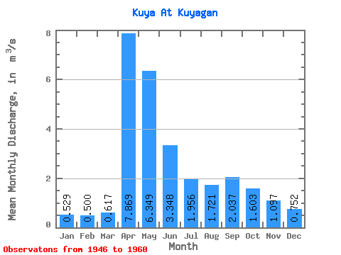
| Statistic | Jan | Feb | Mar | Apr | May | Jun | Jul | Aug | Sep | Oct | Nov | Dec | Annual |
|---|---|---|---|---|---|---|---|---|---|---|---|---|---|
| Mean | 0.53 | 0.50 | 0.62 | 7.87 | 6.35 | 3.35 | 1.96 | 1.72 | 2.04 | 1.60 | 1.10 | 0.75 | 2.29 |
| Standard Deviation | 0.26 | 0.24 | 0.26 | 2.73 | 2.95 | 2.36 | 0.90 | 0.96 | 1.66 | 0.87 | 0.72 | 0.48 | 0.66 |
| Min | 0.26 | 0.13 | 0.24 | 3.00 | 2.54 | 0.86 | 0.53 | 0.59 | 0.59 | 0.61 | 0.35 | 0.33 | 1.21 |
| Max | 1.02 | 1.00 | 1.04 | 12.40 | 12.10 | 9.72 | 3.09 | 4.06 | 6.87 | 3.11 | 2.99 | 2.24 | 3.16 |
| Coefficient of Variation | 0.49 | 0.47 | 0.42 | 0.35 | 0.47 | 0.70 | 0.46 | 0.56 | 0.82 | 0.54 | 0.66 | 0.64 | 0.29 |
 Return to R-Arctic Net Home Page