|
|
|||||||||||||||||
| Point ID: 8404 | Downloads | Plots | Site Data | Code: 9540 |
|
|
|||||||||||||||||
| Download | |
|---|---|
| Site Descriptor Information | Site Time Series Data |
| Link to all available data | |
| View: | Time Series | All |
| Units: | mm |
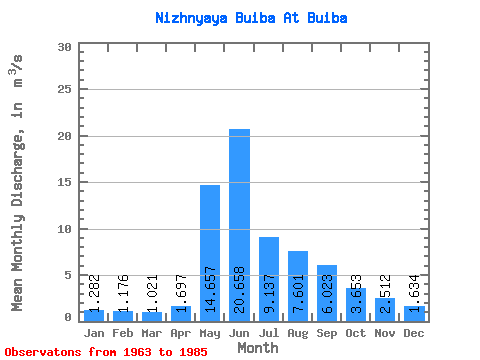
| Statistic | Jan | Feb | Mar | Apr | May | Jun | Jul | Aug | Sep | Oct | Nov | Dec | Annual |
|---|---|---|---|---|---|---|---|---|---|---|---|---|---|
| Mean | 1.28 | 1.18 | 1.02 | 1.70 | 14.66 | 20.66 | 9.14 | 7.60 | 6.02 | 3.65 | 2.51 | 1.63 | 5.82 |
| Standard Deviation | 0.29 | 0.32 | 0.31 | 0.83 | 4.84 | 10.94 | 4.13 | 2.62 | 1.78 | 1.20 | 0.88 | 0.52 | 1.05 |
| Min | 0.83 | 0.63 | 0.51 | 0.75 | 5.98 | 7.51 | 3.77 | 3.01 | 3.45 | 0.00 | 1.35 | 0.97 | 3.92 |
| Max | 1.99 | 1.89 | 1.89 | 3.56 | 24.60 | 49.90 | 20.60 | 13.10 | 10.10 | 5.99 | 5.39 | 3.49 | 7.40 |
| Coefficient of Variation | 0.22 | 0.27 | 0.31 | 0.49 | 0.33 | 0.53 | 0.45 | 0.34 | 0.29 | 0.33 | 0.35 | 0.32 | 0.18 |
 Return to R-Arctic Net Home Page