|
|
|||||||||||||||||
| Point ID: 8386 | Downloads | Plots | Site Data | Code: 9474 |
|
|
|||||||||||||||||
| Download | |
|---|---|
| Site Descriptor Information | Site Time Series Data |
| Link to all available data | |
| View: | Time Series | All |
| Units: | mm |
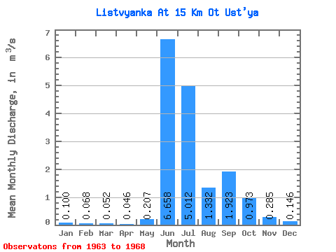
| Statistic | Jan | Feb | Mar | Apr | May | Jun | Jul | Aug | Sep | Oct | Nov | Dec | Annual |
|---|---|---|---|---|---|---|---|---|---|---|---|---|---|
| Mean | 0.10 | 0.07 | 0.05 | 0.05 | 0.21 | 6.66 | 5.01 | 1.33 | 1.92 | 0.97 | 0.28 | 0.15 | 1.40 |
| Standard Deviation | 0.06 | 0.05 | 0.04 | 0.03 | 0.33 | 2.12 | 2.50 | 0.93 | 0.80 | 0.64 | 0.10 | 0.07 | 0.24 |
| Min | 0.00 | 0.00 | 0.00 | 0.00 | 0.00 | 4.77 | 1.71 | 0.60 | 0.72 | 0.48 | 0.13 | 0.02 | 1.07 |
| Max | 0.15 | 0.11 | 0.09 | 0.08 | 0.88 | 9.51 | 9.35 | 3.05 | 2.80 | 2.25 | 0.42 | 0.23 | 1.75 |
| Coefficient of Variation | 0.59 | 0.68 | 0.67 | 0.73 | 1.61 | 0.32 | 0.50 | 0.70 | 0.41 | 0.66 | 0.35 | 0.49 | 0.17 |
 Return to R-Arctic Net Home Page