|
|
|||||||||||||||||
| Point ID: 8363 | Downloads | Plots | Site Data | Code: 9376 |
|
|
|||||||||||||||||
| Download | |
|---|---|
| Site Descriptor Information | Site Time Series Data |
| Link to all available data | |
| View: | Time Series | All |
| Units: | mm |
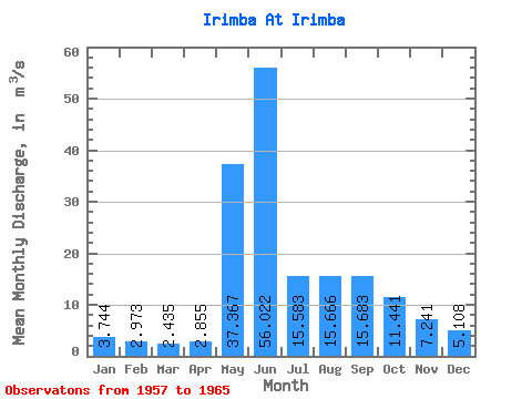
| Statistic | Jan | Feb | Mar | Apr | May | Jun | Jul | Aug | Sep | Oct | Nov | Dec | Annual |
|---|---|---|---|---|---|---|---|---|---|---|---|---|---|
| Mean | 3.74 | 2.97 | 2.44 | 2.85 | 37.37 | 56.02 | 15.58 | 15.67 | 15.68 | 11.44 | 7.24 | 5.11 | 14.68 |
| Standard Deviation | 0.83 | 0.87 | 0.81 | 0.88 | 11.06 | 27.52 | 4.61 | 7.23 | 5.14 | 3.71 | 2.08 | 1.17 | 2.99 |
| Min | 2.80 | 1.47 | 1.42 | 1.58 | 20.10 | 26.60 | 8.65 | 7.25 | 8.60 | 7.07 | 5.09 | 3.69 | 12.08 |
| Max | 5.40 | 3.86 | 3.33 | 3.86 | 51.90 | 117.00 | 22.50 | 27.60 | 22.50 | 16.70 | 11.50 | 7.37 | 20.67 |
| Coefficient of Variation | 0.22 | 0.29 | 0.33 | 0.31 | 0.30 | 0.49 | 0.30 | 0.46 | 0.33 | 0.32 | 0.29 | 0.23 | 0.20 |
 Return to R-Arctic Net Home Page