|
|
|||||||||||||||||
| Point ID: 8360 | Downloads | Plots | Site Data | Code: 9361 |
|
|
|||||||||||||||||
| Download | |
|---|---|
| Site Descriptor Information | Site Time Series Data |
| Link to all available data | |
| View: | Time Series | All |
| Units: | mm |
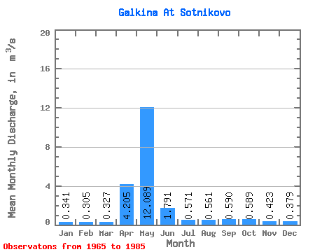
| Statistic | Jan | Feb | Mar | Apr | May | Jun | Jul | Aug | Sep | Oct | Nov | Dec | Annual |
|---|---|---|---|---|---|---|---|---|---|---|---|---|---|
| Mean | 0.34 | 0.30 | 0.33 | 4.21 | 12.09 | 1.79 | 0.57 | 0.56 | 0.59 | 0.59 | 0.42 | 0.38 | 1.85 |
| Standard Deviation | 0.05 | 0.06 | 0.05 | 3.84 | 7.44 | 0.78 | 0.23 | 0.21 | 0.20 | 0.26 | 0.07 | 0.10 | 0.50 |
| Min | 0.22 | 0.22 | 0.24 | 0.36 | 1.89 | 0.62 | 0.38 | 0.39 | 0.42 | 0.41 | 0.34 | 0.22 | 0.68 |
| Max | 0.44 | 0.41 | 0.40 | 10.50 | 26.20 | 3.52 | 1.48 | 1.24 | 1.26 | 1.50 | 0.57 | 0.72 | 2.82 |
| Coefficient of Variation | 0.16 | 0.18 | 0.15 | 0.91 | 0.62 | 0.44 | 0.41 | 0.37 | 0.33 | 0.44 | 0.17 | 0.25 | 0.27 |
 Return to R-Arctic Net Home Page