|
|
|||||||||||||||||
| Point ID: 8328 | Downloads | Plots | Site Data | Code: 9271 |
|
|
|||||||||||||||||
| Download | |
|---|---|
| Site Descriptor Information | Site Time Series Data |
| Link to all available data | |
| View: | Time Series | All |
| Units: | mm |
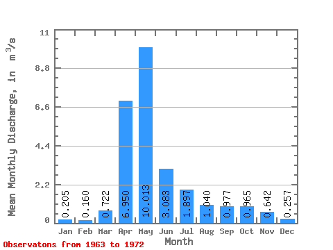
| Statistic | Jan | Feb | Mar | Apr | May | Jun | Jul | Aug | Sep | Oct | Nov | Dec | Annual |
|---|---|---|---|---|---|---|---|---|---|---|---|---|---|
| Mean | 0.20 | 0.16 | 0.72 | 6.95 | 10.01 | 3.08 | 1.90 | 1.04 | 0.98 | 0.96 | 0.64 | 0.26 | 2.19 |
| Standard Deviation | 0.05 | 0.01 | 1.22 | 4.10 | 4.64 | 1.74 | 1.44 | 0.65 | 0.60 | 0.79 | 0.53 | 0.10 | 0.56 |
| Min | 0.16 | 0.15 | 0.14 | 0.31 | 4.22 | 1.36 | 0.58 | 0.37 | 0.28 | 0.32 | 0.22 | 0.16 | 1.57 |
| Max | 0.28 | 0.18 | 3.20 | 12.10 | 15.30 | 6.50 | 4.35 | 2.01 | 1.76 | 1.98 | 1.55 | 0.43 | 2.64 |
| Coefficient of Variation | 0.22 | 0.08 | 1.69 | 0.59 | 0.46 | 0.57 | 0.76 | 0.62 | 0.62 | 0.81 | 0.83 | 0.38 | 0.25 |
 Return to R-Arctic Net Home Page