|
|
|||||||||||||||||
| Point ID: 8322 | Downloads | Plots | Site Data | Code: 9233 |
|
|
|||||||||||||||||
| Download | |
|---|---|
| Site Descriptor Information | Site Time Series Data |
| Link to all available data | |
| View: | Time Series | All |
| Units: | mm |
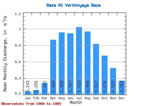
| Statistic | Jan | Feb | Mar | Apr | May | Jun | Jul | Aug | Sep | Oct | Nov | Dec | Annual |
|---|---|---|---|---|---|---|---|---|---|---|---|---|---|
| Mean | 0.24 | 0.26 | 0.34 | 0.87 | 0.96 | 0.95 | 1.02 | 0.97 | 0.82 | 0.68 | 0.52 | 0.37 | 0.66 |
| Standard Deviation | 0.10 | 0.15 | 0.12 | 0.36 | 0.39 | 0.55 | 0.56 | 0.45 | 0.35 | 0.23 | 0.18 | 0.19 | 0.24 |
| Min | 0.03 | 0.01 | 0.01 | 0.30 | 0.53 | 0.48 | 0.44 | 0.41 | 0.42 | 0.33 | 0.22 | 0.11 | 0.40 |
| Max | 0.43 | 0.53 | 0.53 | 1.59 | 1.86 | 2.23 | 2.31 | 2.10 | 1.60 | 1.09 | 0.83 | 0.76 | 1.23 |
| Coefficient of Variation | 0.43 | 0.57 | 0.36 | 0.42 | 0.40 | 0.58 | 0.54 | 0.47 | 0.43 | 0.34 | 0.35 | 0.50 | 0.36 |
 Return to R-Arctic Net Home Page