|
|
|||||||||||||||||
| Point ID: 8314 | Downloads | Plots | Site Data | Code: 9201 |
|
|
|||||||||||||||||
| Download | |
|---|---|
| Site Descriptor Information | Site Time Series Data |
| Link to all available data | |
| View: | Time Series | All |
| Units: | mm |
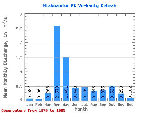
| Statistic | Jan | Feb | Mar | Apr | May | Jun | Jul | Aug | Sep | Oct | Nov | Dec | Annual |
|---|---|---|---|---|---|---|---|---|---|---|---|---|---|
| Mean | 0.08 | 0.06 | 0.27 | 2.58 | 1.49 | 0.44 | 0.46 | 0.34 | 0.38 | 0.52 | 0.25 | 0.10 | 0.58 |
| Standard Deviation | 0.05 | 0.04 | 0.28 | 0.55 | 0.64 | 0.29 | 0.64 | 0.36 | 0.26 | 0.28 | 0.18 | 0.09 | 0.13 |
| Min | 0.01 | 0.01 | 0.02 | 1.76 | 0.47 | 0.05 | 0.03 | 0.03 | 0.05 | 0.16 | 0.04 | 0.03 | 0.38 |
| Max | 0.21 | 0.16 | 0.88 | 3.66 | 2.54 | 1.00 | 2.42 | 1.36 | 1.02 | 1.06 | 0.73 | 0.32 | 0.79 |
| Coefficient of Variation | 0.66 | 0.63 | 1.03 | 0.21 | 0.43 | 0.66 | 1.38 | 1.04 | 0.69 | 0.54 | 0.72 | 0.83 | 0.23 |
 Return to R-Arctic Net Home Page