|
|
|||||||||||||||||
| Point ID: 8313 | Downloads | Plots | Site Data | Code: 9196 |
|
|
|||||||||||||||||
| Download | |
|---|---|
| Site Descriptor Information | Site Time Series Data |
| Link to all available data | |
| View: | Time Series | All |
| Units: | mm |
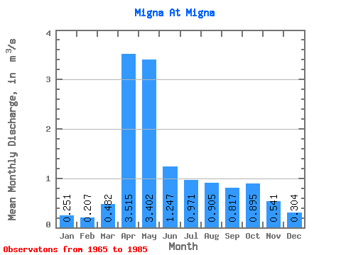
| Statistic | Jan | Feb | Mar | Apr | May | Jun | Jul | Aug | Sep | Oct | Nov | Dec | Annual |
|---|---|---|---|---|---|---|---|---|---|---|---|---|---|
| Mean | 0.25 | 0.21 | 0.48 | 3.52 | 3.40 | 1.25 | 0.97 | 0.91 | 0.82 | 0.90 | 0.54 | 0.30 | 1.13 |
| Standard Deviation | 0.11 | 0.10 | 0.30 | 1.55 | 1.84 | 0.61 | 1.16 | 0.76 | 0.51 | 0.58 | 0.33 | 0.14 | 0.35 |
| Min | 0.05 | 0.07 | 0.12 | 1.24 | 0.77 | 0.39 | 0.25 | 0.22 | 0.25 | 0.26 | 0.19 | 0.15 | 0.61 |
| Max | 0.55 | 0.45 | 1.14 | 7.07 | 8.22 | 2.53 | 5.05 | 2.60 | 1.87 | 2.18 | 1.48 | 0.68 | 1.84 |
| Coefficient of Variation | 0.44 | 0.46 | 0.62 | 0.44 | 0.54 | 0.49 | 1.20 | 0.83 | 0.62 | 0.65 | 0.60 | 0.45 | 0.31 |
 Return to R-Arctic Net Home Page