|
|
|||||||||||||||||
| Point ID: 8310 | Downloads | Plots | Site Data | Code: 9189 |
|
|
|||||||||||||||||
| Download | |
|---|---|
| Site Descriptor Information | Site Time Series Data |
| Link to all available data | |
| View: | Time Series | All |
| Units: | mm |
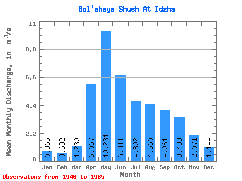
| Statistic | Jan | Feb | Mar | Apr | May | Jun | Jul | Aug | Sep | Oct | Nov | Dec | Annual |
|---|---|---|---|---|---|---|---|---|---|---|---|---|---|
| Mean | 0.86 | 0.63 | 1.23 | 6.07 | 10.23 | 6.81 | 4.80 | 4.56 | 4.06 | 3.48 | 2.07 | 1.14 | 3.80 |
| Standard Deviation | 0.43 | 0.43 | 0.98 | 2.72 | 4.65 | 3.02 | 3.36 | 2.67 | 1.75 | 1.43 | 0.92 | 0.43 | 1.09 |
| Min | 0.10 | 0.08 | 0.05 | 2.42 | 3.56 | 2.59 | 1.61 | 1.07 | 1.82 | 1.50 | 0.78 | 0.27 | 2.00 |
| Max | 2.04 | 2.24 | 4.83 | 14.10 | 22.00 | 14.90 | 15.90 | 12.30 | 8.67 | 7.41 | 4.80 | 2.31 | 6.23 |
| Coefficient of Variation | 0.49 | 0.68 | 0.80 | 0.45 | 0.46 | 0.44 | 0.70 | 0.59 | 0.43 | 0.41 | 0.44 | 0.38 | 0.29 |
 Return to R-Arctic Net Home Page