|
|
|||||||||||||||||
| Point ID: 8308 | Downloads | Plots | Site Data | Code: 9185 |
|
|
|||||||||||||||||
| Download | |
|---|---|
| Site Descriptor Information | Site Time Series Data |
| Link to all available data | |
| View: | Time Series | All |
| Units: | mm |
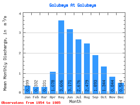
| Statistic | Jan | Feb | Mar | Apr | May | Jun | Jul | Aug | Sep | Oct | Nov | Dec | Annual |
|---|---|---|---|---|---|---|---|---|---|---|---|---|---|
| Mean | 0.40 | 0.33 | 0.33 | 1.08 | 3.61 | 3.17 | 2.68 | 2.48 | 1.89 | 1.34 | 0.84 | 0.54 | 1.56 |
| Standard Deviation | 0.14 | 0.10 | 0.08 | 0.67 | 1.53 | 1.37 | 1.66 | 1.30 | 0.77 | 0.51 | 0.31 | 0.17 | 0.42 |
| Min | 0.22 | 0.09 | 0.18 | 0.36 | 0.97 | 1.25 | 0.95 | 0.62 | 0.89 | 0.68 | 0.40 | 0.30 | 0.82 |
| Max | 0.73 | 0.53 | 0.55 | 3.24 | 6.65 | 5.89 | 6.87 | 5.76 | 3.98 | 2.88 | 1.44 | 0.89 | 2.34 |
| Coefficient of Variation | 0.35 | 0.32 | 0.25 | 0.62 | 0.42 | 0.43 | 0.62 | 0.52 | 0.41 | 0.38 | 0.36 | 0.31 | 0.27 |
 Return to R-Arctic Net Home Page