|
|
|||||||||||||||||
| Point ID: 8306 | Downloads | Plots | Site Data | Code: 9183 |
|
|
|||||||||||||||||
| Download | |
|---|---|
| Site Descriptor Information | Site Time Series Data |
| Link to all available data | |
| View: | Time Series | All |
| Units: | mm |
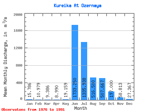
| Statistic | Jan | Feb | Mar | Apr | May | Jun | Jul | Aug | Sep | Oct | Nov | Dec | Annual |
|---|---|---|---|---|---|---|---|---|---|---|---|---|---|
| Mean | 15.79 | 10.98 | 9.39 | 8.99 | 19.16 | 1733.25 | 1335.94 | 516.50 | 507.67 | 197.00 | 58.81 | 27.37 | 359.56 |
| Standard Deviation | 4.83 | 4.48 | 3.11 | 2.19 | 17.34 | 719.71 | 693.63 | 256.69 | 200.67 | 104.43 | 28.84 | 12.15 | 56.42 |
| Min | 7.37 | 4.92 | 5.57 | 6.57 | 8.37 | 362.00 | 614.00 | 215.00 | 152.00 | 89.60 | 26.10 | 16.60 | 260.27 |
| Max | 27.00 | 21.60 | 16.80 | 14.50 | 76.30 | 3250.00 | 3000.00 | 941.00 | 896.00 | 528.00 | 148.00 | 66.40 | 488.14 |
| Coefficient of Variation | 0.31 | 0.41 | 0.33 | 0.24 | 0.91 | 0.41 | 0.52 | 0.50 | 0.40 | 0.53 | 0.49 | 0.44 | 0.16 |
 Return to R-Arctic Net Home Page