|
|
|||||||||||||||||
| Point ID: 8301 | Downloads | Plots | Site Data | Code: 9176 |
|
|
|||||||||||||||||
| Download | |
|---|---|
| Site Descriptor Information | Site Time Series Data |
| Link to all available data | |
| View: | Time Series | All |
| Units: | mm |
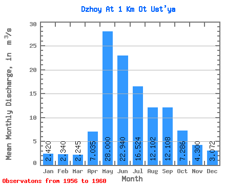
| Statistic | Jan | Feb | Mar | Apr | May | Jun | Jul | Aug | Sep | Oct | Nov | Dec | Annual |
|---|---|---|---|---|---|---|---|---|---|---|---|---|---|
| Mean | 2.42 | 2.34 | 2.25 | 7.04 | 28.00 | 22.94 | 16.52 | 12.10 | 12.11 | 7.29 | 4.30 | 3.07 | 10.86 |
| Standard Deviation | 0.32 | 0.42 | 0.44 | 1.77 | 10.11 | 6.77 | 7.69 | 4.17 | 4.17 | 1.82 | 1.39 | 0.69 | 0.95 |
| Min | 1.98 | 1.76 | 1.87 | 4.54 | 15.20 | 17.70 | 8.42 | 5.41 | 8.17 | 5.21 | 3.17 | 2.19 | 10.09 |
| Max | 2.69 | 2.76 | 2.85 | 8.41 | 41.10 | 33.50 | 27.70 | 16.30 | 17.90 | 9.69 | 6.62 | 4.08 | 12.06 |
| Coefficient of Variation | 0.13 | 0.18 | 0.20 | 0.25 | 0.36 | 0.29 | 0.47 | 0.34 | 0.34 | 0.25 | 0.32 | 0.22 | 0.09 |
 Return to R-Arctic Net Home Page