|
|
|||||||||||||||||
| Point ID: 8276 | Downloads | Plots | Site Data | Code: 8401 |
|
|
|||||||||||||||||
| Download | |
|---|---|
| Site Descriptor Information | Site Time Series Data |
| Link to all available data | |
| View: | Time Series | All |
| Units: | mm |
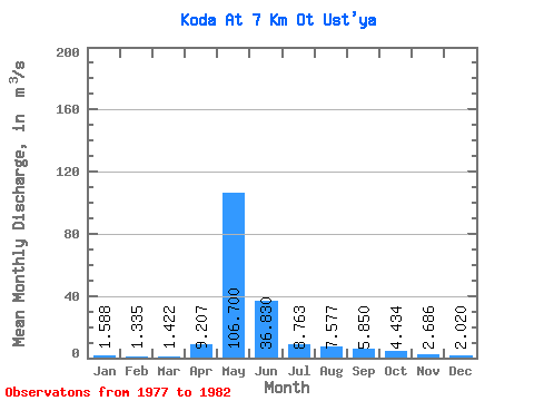
| Statistic | Jan | Feb | Mar | Apr | May | Jun | Jul | Aug | Sep | Oct | Nov | Dec | Annual |
|---|---|---|---|---|---|---|---|---|---|---|---|---|---|
| Mean | 1.59 | 1.33 | 1.42 | 9.21 | 106.70 | 36.83 | 8.76 | 7.58 | 5.85 | 4.43 | 2.69 | 2.02 | 15.37 |
| Standard Deviation | 0.18 | 0.16 | 0.24 | 10.97 | 29.92 | 15.54 | 5.36 | 6.17 | 1.61 | 0.74 | 0.54 | 0.32 | 3.48 |
| Min | 1.36 | 1.11 | 1.10 | 1.50 | 68.40 | 9.78 | 5.69 | 4.16 | 3.83 | 3.61 | 2.24 | 1.73 | 11.21 |
| Max | 1.84 | 1.50 | 1.81 | 28.40 | 153.00 | 56.10 | 19.50 | 20.10 | 8.02 | 5.45 | 3.62 | 2.55 | 20.62 |
| Coefficient of Variation | 0.11 | 0.12 | 0.17 | 1.19 | 0.28 | 0.42 | 0.61 | 0.81 | 0.28 | 0.17 | 0.20 | 0.16 | 0.23 |
 Return to R-Arctic Net Home Page