|
|
|||||||||||||||||
| Point ID: 8268 | Downloads | Plots | Site Data | Code: 8384 |
|
|
|||||||||||||||||
| Download | |
|---|---|
| Site Descriptor Information | Site Time Series Data |
| Link to all available data | |
| View: | Time Series | All |
| Units: | mm |
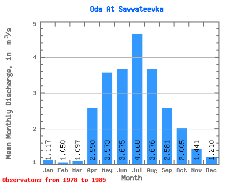
| Statistic | Jan | Feb | Mar | Apr | May | Jun | Jul | Aug | Sep | Oct | Nov | Dec | Annual |
|---|---|---|---|---|---|---|---|---|---|---|---|---|---|
| Mean | 1.12 | 1.05 | 1.10 | 2.59 | 3.57 | 3.67 | 4.67 | 3.68 | 2.58 | 2.00 | 1.44 | 1.21 | 2.44 |
| Standard Deviation | 0.25 | 0.23 | 0.25 | 0.87 | 0.56 | 1.18 | 2.15 | 1.77 | 0.91 | 0.62 | 0.44 | 0.40 | 0.56 |
| Min | 0.85 | 0.77 | 0.81 | 1.72 | 2.71 | 2.17 | 2.38 | 1.81 | 1.70 | 1.43 | 1.00 | 0.75 | 1.73 |
| Max | 1.57 | 1.37 | 1.46 | 4.28 | 4.39 | 5.54 | 9.17 | 7.15 | 4.31 | 2.99 | 2.24 | 1.97 | 3.29 |
| Coefficient of Variation | 0.23 | 0.22 | 0.23 | 0.33 | 0.16 | 0.32 | 0.46 | 0.48 | 0.35 | 0.31 | 0.31 | 0.33 | 0.23 |
 Return to R-Arctic Net Home Page