|
|
|||||||||||||||||
| Point ID: 8225 | Downloads | Plots | Site Data | Code: 8270 |
|
|
|||||||||||||||||
| Download | |
|---|---|
| Site Descriptor Information | Site Time Series Data |
| Link to all available data | |
| View: | Time Series | All |
| Units: | mm |
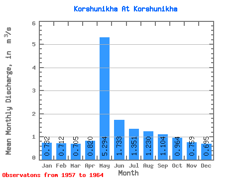
| Statistic | Jan | Feb | Mar | Apr | May | Jun | Jul | Aug | Sep | Oct | Nov | Dec | Annual |
|---|---|---|---|---|---|---|---|---|---|---|---|---|---|
| Mean | 0.73 | 0.71 | 0.70 | 0.82 | 5.29 | 1.73 | 1.35 | 1.23 | 1.10 | 0.96 | 0.76 | 0.69 | 1.28 |
| Standard Deviation | 0.04 | 0.04 | 0.06 | 0.25 | 1.18 | 0.65 | 0.52 | 0.39 | 0.29 | 0.26 | 0.16 | 0.09 | 0.24 |
| Min | 0.69 | 0.65 | 0.66 | 0.59 | 3.40 | 0.81 | 0.73 | 0.70 | 0.73 | 0.64 | 0.55 | 0.56 | 0.93 |
| Max | 0.80 | 0.77 | 0.82 | 1.31 | 6.79 | 2.45 | 2.12 | 1.85 | 1.60 | 1.41 | 0.94 | 0.81 | 1.54 |
| Coefficient of Variation | 0.06 | 0.06 | 0.09 | 0.30 | 0.22 | 0.37 | 0.38 | 0.32 | 0.26 | 0.27 | 0.21 | 0.12 | 0.19 |
 Return to R-Arctic Net Home Page