|
|
|||||||||||||||||
| Point ID: 8219 | Downloads | Plots | Site Data | Code: 8249 |
|
|
|||||||||||||||||
| Download | |
|---|---|
| Site Descriptor Information | Site Time Series Data |
| Link to all available data | |
| View: | Time Series | All |
| Units: | mm |
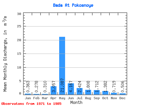
| Statistic | Jan | Feb | Mar | Apr | May | Jun | Jul | Aug | Sep | Oct | Nov | Dec | Annual |
|---|---|---|---|---|---|---|---|---|---|---|---|---|---|
| Mean | 0.36 | 0.28 | 0.31 | 3.06 | 21.09 | 4.17 | 2.42 | 1.81 | 1.71 | 1.38 | 0.72 | 0.51 | 3.15 |
| Standard Deviation | 0.19 | 0.15 | 0.13 | 3.64 | 8.34 | 1.96 | 1.66 | 1.21 | 0.68 | 0.71 | 0.26 | 0.24 | 0.77 |
| Min | 0.14 | 0.10 | 0.09 | 0.39 | 7.68 | 1.63 | 1.13 | 0.65 | 0.97 | 0.90 | 0.49 | 0.21 | 1.92 |
| Max | 0.73 | 0.63 | 0.49 | 11.70 | 32.60 | 7.55 | 6.26 | 4.84 | 2.94 | 2.93 | 1.26 | 0.93 | 4.42 |
| Coefficient of Variation | 0.53 | 0.54 | 0.42 | 1.19 | 0.40 | 0.47 | 0.68 | 0.67 | 0.40 | 0.51 | 0.37 | 0.48 | 0.24 |
 Return to R-Arctic Net Home Page