|
|
|||||||||||||||||
| Point ID: 8210 | Downloads | Plots | Site Data | Code: 8221 |
|
|
|||||||||||||||||
| Download | |
|---|---|
| Site Descriptor Information | Site Time Series Data |
| Link to all available data | |
| View: | Time Series | All |
| Units: | mm |
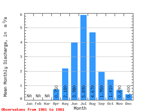
| Statistic | Jan | Feb | Mar | Apr | May | Jun | Jul | Aug | Sep | Oct | Nov | Dec | Annual |
|---|---|---|---|---|---|---|---|---|---|---|---|---|---|
| Mean | 0.75 | 2.18 | 3.98 | 5.89 | 4.67 | 1.95 | 1.41 | 0.69 | 0.40 | ||||
| Standard Deviation | |||||||||||||
| Min | 0.75 | 2.18 | 3.98 | 5.89 | 4.67 | 1.95 | 1.41 | 0.69 | 0.40 | ||||
| Max | 0.75 | 2.18 | 3.98 | 5.89 | 4.67 | 1.95 | 1.41 | 0.69 | 0.40 | ||||
| Coefficient of Variation |
 Return to R-Arctic Net Home Page