|
|
|||||||||||||||||
| Point ID: 8209 | Downloads | Plots | Site Data | Code: 8220 |
|
|
|||||||||||||||||
| Download | |
|---|---|
| Site Descriptor Information | Site Time Series Data |
| Link to all available data | |
| View: | Time Series | All |
| Units: | mm |
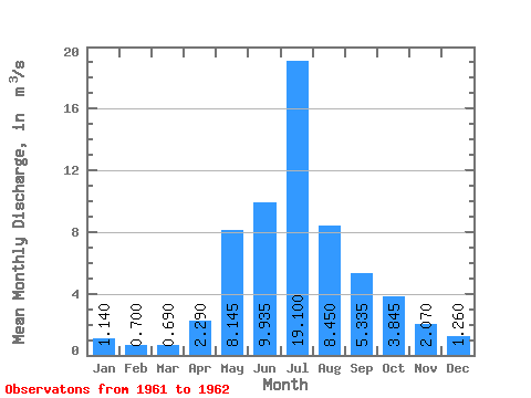
| Statistic | Jan | Feb | Mar | Apr | May | Jun | Jul | Aug | Sep | Oct | Nov | Dec | Annual |
|---|---|---|---|---|---|---|---|---|---|---|---|---|---|
| Mean | 1.14 | 0.70 | 0.69 | 2.29 | 8.14 | 9.94 | 19.10 | 8.45 | 5.33 | 3.84 | 2.07 | 1.26 | 5.46 |
| Standard Deviation | 0.68 | 2.77 | 0.52 | 5.23 | 3.75 | 1.36 | 0.56 | 0.13 | 0.20 | ||||
| Min | 1.14 | 0.70 | 0.69 | 1.81 | 6.19 | 9.57 | 15.40 | 5.80 | 4.37 | 3.45 | 1.98 | 1.12 | 5.46 |
| Max | 1.14 | 0.70 | 0.69 | 2.77 | 10.10 | 10.30 | 22.80 | 11.10 | 6.30 | 4.24 | 2.16 | 1.40 | 5.46 |
| Coefficient of Variation | 0.30 | 0.34 | 0.05 | 0.27 | 0.44 | 0.26 | 0.14 | 0.06 | 0.16 |
 Return to R-Arctic Net Home Page