|
|
|||||||||||||||||
| Point ID: 8191 | Downloads | Plots | Site Data | Code: 8179 |
|
|
|||||||||||||||||
| Download | |
|---|---|
| Site Descriptor Information | Site Time Series Data |
| Link to all available data | |
| View: | Time Series | All |
| Units: | mm |
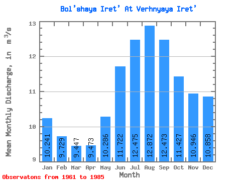
| Statistic | Jan | Feb | Mar | Apr | May | Jun | Jul | Aug | Sep | Oct | Nov | Dec | Annual |
|---|---|---|---|---|---|---|---|---|---|---|---|---|---|
| Mean | 10.24 | 9.73 | 9.45 | 9.47 | 10.29 | 11.72 | 12.47 | 12.87 | 12.47 | 11.43 | 10.95 | 10.86 | 10.96 |
| Standard Deviation | 0.75 | 0.49 | 0.32 | 0.30 | 0.41 | 0.75 | 0.87 | 0.87 | 0.89 | 0.84 | 0.92 | 0.94 | 0.50 |
| Min | 9.11 | 9.05 | 8.86 | 9.10 | 9.68 | 10.20 | 11.30 | 11.60 | 10.80 | 10.10 | 9.64 | 9.56 | 10.24 |
| Max | 11.50 | 10.60 | 10.20 | 10.30 | 11.10 | 12.90 | 14.60 | 14.30 | 13.60 | 12.70 | 12.50 | 12.10 | 11.88 |
| Coefficient of Variation | 0.07 | 0.05 | 0.03 | 0.03 | 0.04 | 0.06 | 0.07 | 0.07 | 0.07 | 0.07 | 0.08 | 0.09 | 0.05 |
 Return to R-Arctic Net Home Page