|
|
|||||||||||||||||
| Point ID: 8189 | Downloads | Plots | Site Data | Code: 8167 |
|
|
|||||||||||||||||
| Download | |
|---|---|
| Site Descriptor Information | Site Time Series Data |
| Link to all available data | |
| View: | Time Series | All |
| Units: | mm |
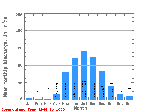
| Statistic | Jan | Feb | Mar | Apr | May | Jun | Jul | Aug | Sep | Oct | Nov | Dec | Annual |
|---|---|---|---|---|---|---|---|---|---|---|---|---|---|
| Mean | 5.55 | 3.45 | 3.39 | 13.37 | 63.59 | 96.23 | 113.74 | 98.36 | 66.25 | 30.97 | 13.90 | 9.84 | 43.25 |
| Standard Deviation | 1.49 | 1.04 | 1.01 | 6.84 | 21.21 | 35.77 | 41.55 | 26.24 | 23.07 | 7.25 | 4.22 | 3.50 | 6.91 |
| Min | 2.62 | 1.70 | 1.20 | 5.62 | 31.10 | 52.50 | 54.30 | 59.60 | 43.50 | 18.80 | 6.64 | 3.96 | 33.15 |
| Max | 8.34 | 5.59 | 5.67 | 26.80 | 102.00 | 177.00 | 199.00 | 156.00 | 147.00 | 44.40 | 20.30 | 18.00 | 56.79 |
| Coefficient of Variation | 0.27 | 0.30 | 0.30 | 0.51 | 0.33 | 0.37 | 0.36 | 0.27 | 0.35 | 0.23 | 0.30 | 0.36 | 0.16 |
 Return to R-Arctic Net Home Page