|
|
|||||||||||||||||
| Point ID: 8187 | Downloads | Plots | Site Data | Code: 8165 |
|
|
|||||||||||||||||
| Download | |
|---|---|
| Site Descriptor Information | Site Time Series Data |
| Link to all available data | |
| View: | Time Series | All |
| Units: | mm |
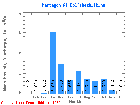
| Statistic | Jan | Feb | Mar | Apr | May | Jun | Jul | Aug | Sep | Oct | Nov | Dec | Annual |
|---|---|---|---|---|---|---|---|---|---|---|---|---|---|
| Mean | 0.00 | 0.00 | 0.05 | 3.05 | 1.46 | 0.69 | 1.12 | 0.71 | 0.60 | 0.73 | 0.17 | 0.01 | 0.70 |
| Standard Deviation | 0.00 | 0.00 | 0.09 | 1.67 | 0.82 | 0.42 | 1.13 | 0.48 | 0.46 | 0.88 | 0.16 | 0.02 | 0.32 |
| Min | 0.00 | 0.00 | 0.00 | 1.12 | 0.43 | 0.25 | 0.13 | 0.16 | 0.04 | 0.05 | 0.00 | 0.00 | 0.30 |
| Max | 0.00 | 0.00 | 0.33 | 7.95 | 3.25 | 1.64 | 4.61 | 2.02 | 1.40 | 3.68 | 0.64 | 0.08 | 1.21 |
| Coefficient of Variation | 1.75 | 0.55 | 0.56 | 0.60 | 1.01 | 0.67 | 0.76 | 1.20 | 0.93 | 1.98 | 0.46 |
 Return to R-Arctic Net Home Page