|
|
|||||||||||||||||
| Point ID: 8180 | Downloads | Plots | Site Data | Code: 8152 |
|
|
|||||||||||||||||
| Download | |
|---|---|
| Site Descriptor Information | Site Time Series Data |
| Link to all available data | |
| View: | Time Series | All |
| Units: | mm |
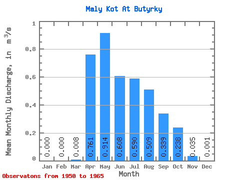
| Statistic | Jan | Feb | Mar | Apr | May | Jun | Jul | Aug | Sep | Oct | Nov | Dec | Annual |
|---|---|---|---|---|---|---|---|---|---|---|---|---|---|
| Mean | 0.00 | 0.00 | 0.01 | 0.76 | 0.91 | 0.61 | 0.59 | 0.51 | 0.34 | 0.24 | 0.04 | 0.00 | 0.31 |
| Standard Deviation | 0.00 | 0.00 | 0.02 | 0.28 | 0.58 | 0.47 | 0.57 | 0.44 | 0.22 | 0.17 | 0.03 | 0.00 | 0.10 |
| Min | 0.00 | 0.00 | 0.00 | 0.33 | 0.18 | 0.17 | 0.08 | 0.07 | 0.03 | 0.02 | 0.00 | 0.00 | 0.15 |
| Max | 0.00 | 0.00 | 0.06 | 1.32 | 2.15 | 1.92 | 2.02 | 1.95 | 0.87 | 0.71 | 0.10 | 0.01 | 0.48 |
| Coefficient of Variation | 2.12 | 0.36 | 0.64 | 0.77 | 0.96 | 0.87 | 0.66 | 0.72 | 0.97 | 2.91 | 0.34 |
 Return to R-Arctic Net Home Page