|
|
|||||||||||||||||
| Point ID: 8173 | Downloads | Plots | Site Data | Code: 8139 |
|
|
|||||||||||||||||
| Download | |
|---|---|
| Site Descriptor Information | Site Time Series Data |
| Link to all available data | |
| View: | Time Series | All |
| Units: | mm |
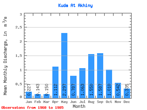
| Statistic | Jan | Feb | Mar | Apr | May | Jun | Jul | Aug | Sep | Oct | Nov | Dec | Annual |
|---|---|---|---|---|---|---|---|---|---|---|---|---|---|
| Mean | 0.23 | 0.14 | 0.15 | 1.11 | 2.30 | 0.79 | 1.06 | 1.55 | 1.59 | 1.01 | 0.54 | 0.34 | 0.90 |
| Standard Deviation | 0.13 | 0.07 | 0.08 | 0.99 | 1.38 | 0.73 | 0.72 | 1.06 | 1.25 | 0.58 | 0.31 | 0.19 | 0.40 |
| Min | 0.04 | 0.02 | 0.03 | 0.11 | 0.47 | 0.17 | 0.18 | 0.18 | 0.19 | 0.19 | 0.09 | 0.06 | 0.29 |
| Max | 0.49 | 0.26 | 0.33 | 3.67 | 4.65 | 3.70 | 2.70 | 3.60 | 5.75 | 2.26 | 1.13 | 0.72 | 1.93 |
| Coefficient of Variation | 0.59 | 0.51 | 0.51 | 0.89 | 0.60 | 0.93 | 0.67 | 0.69 | 0.79 | 0.57 | 0.57 | 0.58 | 0.45 |
 Return to R-Arctic Net Home Page