|
|
|||||||||||||||||
| Point ID: 8170 | Downloads | Plots | Site Data | Code: 8136 |
|
|
|||||||||||||||||
| Download | |
|---|---|
| Site Descriptor Information | Site Time Series Data |
| Link to all available data | |
| View: | Time Series | All |
| Units: | mm |
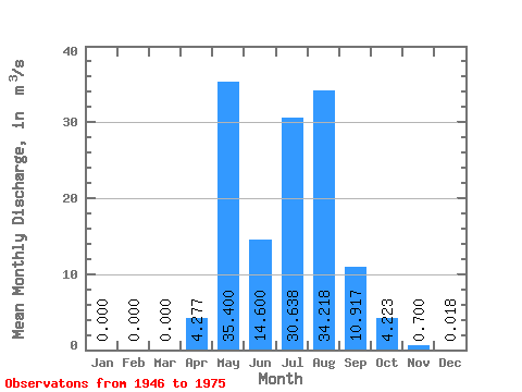
| Statistic | Jan | Feb | Mar | Apr | May | Jun | Jul | Aug | Sep | Oct | Nov | Dec | Annual |
|---|---|---|---|---|---|---|---|---|---|---|---|---|---|
| Mean | 0.00 | 0.00 | 0.00 | 4.28 | 35.40 | 14.60 | 30.64 | 34.22 | 10.92 | 4.22 | 0.70 | 0.02 | 11.67 |
| Standard Deviation | 0.00 | 0.00 | 0.00 | 6.13 | 35.44 | 14.66 | 31.60 | 45.39 | 10.40 | 4.09 | 0.70 | 0.04 | 6.72 |
| Min | 0.00 | 0.00 | 0.00 | 0.00 | 2.70 | 1.30 | 2.50 | 1.30 | 0.30 | 0.00 | 0.00 | 0.00 | 1.75 |
| Max | 0.00 | 0.00 | 0.00 | 20.00 | 115.00 | 53.60 | 120.00 | 147.00 | 29.50 | 12.50 | 2.00 | 0.10 | 21.33 |
| Coefficient of Variation | 1.43 | 1.00 | 1.00 | 1.03 | 1.33 | 0.95 | 0.97 | 1.00 | 2.12 | 0.58 |
 Return to R-Arctic Net Home Page