|
|
|||||||||||||||||
| Point ID: 8145 | Downloads | Plots | Site Data | Code: 8002 |
|
|
|||||||||||||||||
| Download | |
|---|---|
| Site Descriptor Information | Site Time Series Data |
| Link to all available data | |
| View: | Time Series | All |
| Units: | mm |
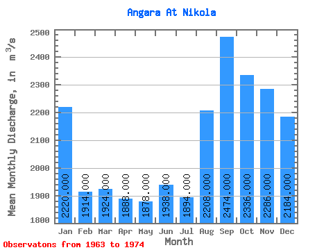
| Statistic | Jan | Feb | Mar | Apr | May | Jun | Jul | Aug | Sep | Oct | Nov | Dec | Annual |
|---|---|---|---|---|---|---|---|---|---|---|---|---|---|
| Mean | 2220.00 | 1914.00 | 1924.00 | 1888.00 | 1878.00 | 1938.00 | 1894.00 | 2208.00 | 2474.00 | 2336.00 | 2286.00 | 2184.00 | 2095.33 |
| Standard Deviation | 389.42 | 262.83 | 272.54 | 369.28 | 299.12 | 283.50 | 570.29 | 605.12 | 999.01 | 702.16 | 518.59 | 523.43 | 321.35 |
| Min | 1890.00 | 1570.00 | 1590.00 | 1590.00 | 1520.00 | 1570.00 | 1510.00 | 1520.00 | 1400.00 | 1570.00 | 1810.00 | 1750.00 | 1849.17 |
| Max | 2830.00 | 2250.00 | 2320.00 | 2460.00 | 2190.00 | 2290.00 | 2890.00 | 3000.00 | 3950.00 | 3340.00 | 3080.00 | 3010.00 | 2497.50 |
| Coefficient of Variation | 0.17 | 0.14 | 0.14 | 0.20 | 0.16 | 0.15 | 0.30 | 0.27 | 0.40 | 0.30 | 0.23 | 0.24 | 0.15 |
 Return to R-Arctic Net Home Page