|
|
|||||||||||||||||
| Point ID: 8144 | Downloads | Plots | Site Data | Code: 8001 |
|
|
|||||||||||||||||
| Download | |
|---|---|
| Site Descriptor Information | Site Time Series Data |
| Link to all available data | |
| View: | Time Series | All |
| Units: | mm |
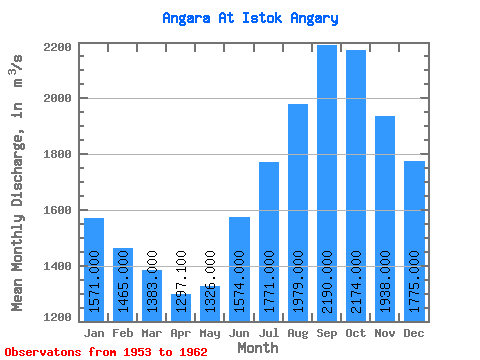
| Statistic | Jan | Feb | Mar | Apr | May | Jun | Jul | Aug | Sep | Oct | Nov | Dec | Annual |
|---|---|---|---|---|---|---|---|---|---|---|---|---|---|
| Mean | 1571.00 | 1465.00 | 1383.00 | 1297.10 | 1326.00 | 1574.00 | 1771.00 | 1979.00 | 2190.00 | 2174.00 | 1938.00 | 1775.00 | 1703.59 |
| Standard Deviation | 269.92 | 253.78 | 295.56 | 290.13 | 253.65 | 178.59 | 257.87 | 371.92 | 352.64 | 402.75 | 276.00 | 346.06 | 199.66 |
| Min | 1240.00 | 1120.00 | 1030.00 | 981.00 | 1060.00 | 1270.00 | 1440.00 | 1530.00 | 1630.00 | 1440.00 | 1390.00 | 1290.00 | 1395.83 |
| Max | 2010.00 | 1810.00 | 1900.00 | 1800.00 | 1700.00 | 1820.00 | 2290.00 | 2600.00 | 2600.00 | 2790.00 | 2370.00 | 2280.00 | 1976.67 |
| Coefficient of Variation | 0.17 | 0.17 | 0.21 | 0.22 | 0.19 | 0.11 | 0.15 | 0.19 | 0.16 | 0.18 | 0.14 | 0.20 | 0.12 |
 Return to R-Arctic Net Home Page