|
|
|||||||||||||||||
| Point ID: 8140 | Downloads | Plots | Site Data | Code: 7195 |
|
|
|||||||||||||||||
| Download | |
|---|---|
| Site Descriptor Information | Site Time Series Data |
| Link to all available data | |
| View: | Time Series | All |
| Units: | mm |
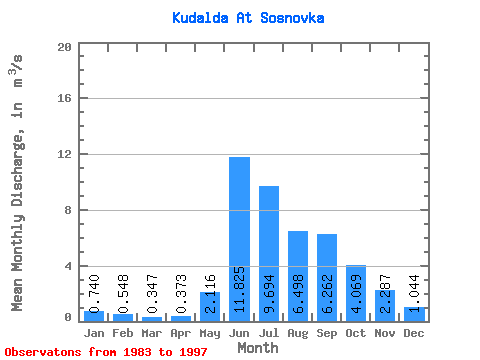
| Statistic | Jan | Feb | Mar | Apr | May | Jun | Jul | Aug | Sep | Oct | Nov | Dec | Annual |
|---|---|---|---|---|---|---|---|---|---|---|---|---|---|
| Mean | 0.74 | 0.55 | 0.35 | 0.37 | 2.12 | 11.82 | 9.69 | 6.50 | 6.26 | 4.07 | 2.29 | 1.04 | 3.91 |
| Standard Deviation | 0.45 | 0.31 | 0.22 | 0.20 | 1.76 | 4.03 | 3.00 | 2.65 | 2.92 | 2.02 | 1.01 | 0.56 | 0.62 |
| Min | 0.06 | 0.18 | 0.11 | 0.07 | 0.48 | 3.81 | 5.87 | 3.10 | 2.34 | 0.95 | 0.42 | 0.18 | 3.08 |
| Max | 1.72 | 1.33 | 1.00 | 0.91 | 6.10 | 18.70 | 15.80 | 12.90 | 12.60 | 8.24 | 4.26 | 2.23 | 5.32 |
| Coefficient of Variation | 0.60 | 0.56 | 0.65 | 0.54 | 0.83 | 0.34 | 0.31 | 0.41 | 0.47 | 0.49 | 0.44 | 0.54 | 0.16 |
 Return to R-Arctic Net Home Page