|
|
|||||||||||||||||
| Point ID: 8120 | Downloads | Plots | Site Data | Code: 1601 |
|
|
|||||||||||||||||
| Download | |
|---|---|
| Site Descriptor Information | Site Time Series Data |
| Link to all available data | |
| View: | Time Series | All |
| Units: | mm |
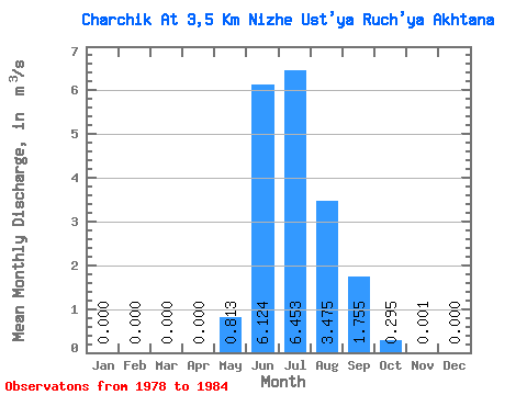
| Statistic | Jan | Feb | Mar | Apr | May | Jun | Jul | Aug | Sep | Oct | Nov | Dec | Annual |
|---|---|---|---|---|---|---|---|---|---|---|---|---|---|
| Mean | 0.00 | 0.00 | 0.00 | 0.00 | 0.81 | 6.12 | 6.45 | 3.48 | 1.75 | 0.29 | 0.00 | 0.00 | 1.61 |
| Standard Deviation | 0.00 | 0.00 | 0.00 | 0.00 | 0.73 | 2.33 | 2.88 | 0.66 | 0.91 | 0.15 | 0.00 | 0.00 | 0.39 |
| Min | 0.00 | 0.00 | 0.00 | 0.00 | 0.08 | 3.40 | 3.74 | 2.40 | 0.76 | 0.12 | 0.00 | 0.00 | 1.13 |
| Max | 0.00 | 0.00 | 0.00 | 0.00 | 2.16 | 9.75 | 11.20 | 4.39 | 3.27 | 0.51 | 0.01 | 0.00 | 2.15 |
| Coefficient of Variation | 0.90 | 0.38 | 0.45 | 0.19 | 0.52 | 0.50 | 2.65 | 0.24 |
 Return to R-Arctic Net Home Page