|
|
|||||||||||||||||
| Point ID: 8104 | Downloads | Plots | Site Data | Code: 1562 |
|
|
|||||||||||||||||
| Download | |
|---|---|
| Site Descriptor Information | Site Time Series Data |
| Link to all available data | |
| View: | Time Series | All |
| Units: | mm |
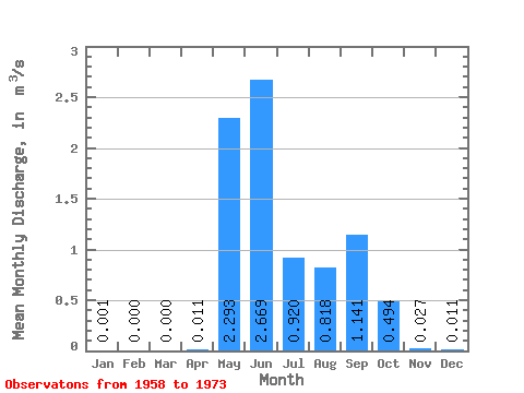
| Statistic | Jan | Feb | Mar | Apr | May | Jun | Jul | Aug | Sep | Oct | Nov | Dec | Annual |
|---|---|---|---|---|---|---|---|---|---|---|---|---|---|
| Mean | 0.00 | 0.00 | 0.00 | 0.01 | 2.29 | 2.67 | 0.92 | 0.82 | 1.14 | 0.49 | 0.03 | 0.01 | 0.70 |
| Standard Deviation | 0.00 | 0.00 | 0.00 | 0.01 | 1.30 | 1.22 | 0.54 | 0.82 | 0.86 | 0.67 | 0.06 | 0.02 | 0.21 |
| Min | 0.00 | 0.00 | 0.00 | 0.00 | 1.16 | 1.21 | 0.12 | 0.07 | 0.00 | 0.00 | 0.00 | 0.00 | 0.35 |
| Max | 0.01 | 0.00 | 0.00 | 0.05 | 6.51 | 5.60 | 2.03 | 3.16 | 2.71 | 2.72 | 0.20 | 0.08 | 1.08 |
| Coefficient of Variation | 2.78 | 1.44 | 0.57 | 0.46 | 0.59 | 1.01 | 0.75 | 1.37 | 2.26 | 2.25 | 0.31 |
 Return to R-Arctic Net Home Page