|
|
|||||||||||||||||
| Point ID: 808 | Downloads | Plots | Site Data | Code: 07OA001 |
|
|
|||||||||||||||||
| Download | |
|---|---|
| Site Descriptor Information | Site Time Series Data |
| Link to all available data | |
| View: | Time Series | All |
| Units: | mm |
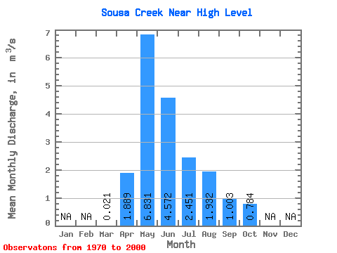
| Statistic | Jan | Feb | Mar | Apr | May | Jun | Jul | Aug | Sep | Oct | Nov | Dec | Annual |
|---|---|---|---|---|---|---|---|---|---|---|---|---|---|
| Mean | 0.02 | 1.89 | 6.83 | 4.57 | 2.45 | 1.93 | 1.00 | 0.78 | |||||
| Standard Deviation | 0.05 | 1.96 | 5.63 | 5.79 | 3.14 | 3.00 | 1.46 | 1.08 | |||||
| Min | 0.00 | 0.01 | 0.12 | 0.12 | 0.01 | 0.01 | 0.00 | 0.01 | |||||
| Max | 0.28 | 9.61 | 19.90 | 28.10 | 14.80 | 9.80 | 6.01 | 4.04 | |||||
| Coefficient of Variation | 2.53 | 1.04 | 0.82 | 1.27 | 1.28 | 1.55 | 1.45 | 1.38 |
 Return to R-Arctic Net Home Page