|
|
|||||||||||||||||
| Point ID: 8079 | Downloads | Plots | Site Data | Code: 1451 |
|
|
|||||||||||||||||
| Download | |
|---|---|
| Site Descriptor Information | Site Time Series Data |
| Link to all available data | |
| View: | Time Series | All |
| Units: | mm |
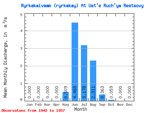
| Statistic | Jan | Feb | Mar | Apr | May | Jun | Jul | Aug | Sep | Oct | Nov | Dec | Annual |
|---|---|---|---|---|---|---|---|---|---|---|---|---|---|
| Mean | 0.00 | 0.00 | 0.00 | 0.00 | 0.51 | 4.47 | 3.18 | 2.31 | 0.36 | 0.06 | 0.00 | 0.00 | 0.91 |
| Standard Deviation | 0.00 | 0.00 | 0.00 | 0.00 | 0.69 | 1.34 | 2.34 | 1.57 | 0.28 | 0.12 | 0.00 | 0.00 | 0.31 |
| Min | 0.00 | 0.00 | 0.00 | 0.00 | 0.00 | 2.57 | 1.23 | 0.55 | 0.06 | 0.00 | 0.00 | 0.00 | 0.56 |
| Max | 0.00 | 0.00 | 0.00 | 0.00 | 2.51 | 7.44 | 9.75 | 6.26 | 1.00 | 0.51 | 0.00 | 0.00 | 1.64 |
| Coefficient of Variation | 1.36 | 0.30 | 0.74 | 0.68 | 0.77 | 2.06 | 4.00 | 0.34 |
 Return to R-Arctic Net Home Page