|
|
|||||||||||||||||
| Point ID: 8045 | Downloads | Plots | Site Data | Code: 1111 |
|
|
|||||||||||||||||
| Download | |
|---|---|
| Site Descriptor Information | Site Time Series Data |
| Link to all available data | |
| View: | Time Series | All |
| Units: | mm |
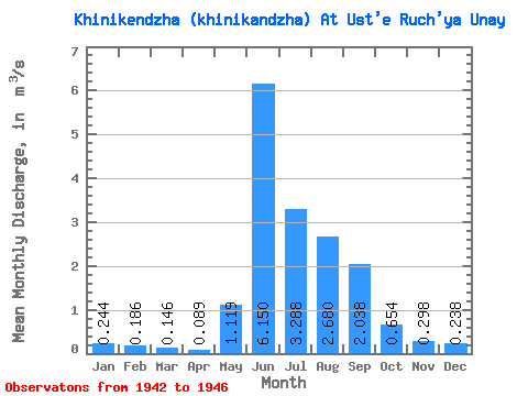
| Statistic | Jan | Feb | Mar | Apr | May | Jun | Jul | Aug | Sep | Oct | Nov | Dec | Annual |
|---|---|---|---|---|---|---|---|---|---|---|---|---|---|
| Mean | 0.24 | 0.19 | 0.15 | 0.09 | 1.12 | 6.15 | 3.29 | 2.68 | 2.04 | 0.65 | 0.30 | 0.24 | 1.65 |
| Standard Deviation | 0.10 | 0.08 | 0.03 | 0.04 | 1.12 | 2.51 | 2.21 | 1.75 | 1.83 | 0.50 | 0.19 | 0.14 | 0.12 |
| Min | 0.14 | 0.11 | 0.12 | 0.06 | 0.00 | 2.67 | 0.00 | 0.00 | 0.00 | 0.00 | 0.00 | 0.00 | 1.54 |
| Max | 0.40 | 0.31 | 0.19 | 0.16 | 2.42 | 8.58 | 6.22 | 4.26 | 4.34 | 1.38 | 0.47 | 0.36 | 1.77 |
| Coefficient of Variation | 0.42 | 0.43 | 0.22 | 0.46 | 1.00 | 0.41 | 0.67 | 0.65 | 0.90 | 0.77 | 0.64 | 0.59 | 0.07 |
 Return to R-Arctic Net Home Page