|
|
|||||||||||||||||
| Point ID: 8032 | Downloads | Plots | Site Data | Code: 1043 |
|
|
|||||||||||||||||
| Download | |
|---|---|
| Site Descriptor Information | Site Time Series Data |
| Link to all available data | |
| View: | Time Series | All |
| Units: | mm |
| Statistic | Jan | Feb | Mar | Apr | May | Jun | Jul | Aug | Sep | Oct | Nov | Dec | Annual |
|---|---|---|---|---|---|---|---|---|---|---|---|---|---|
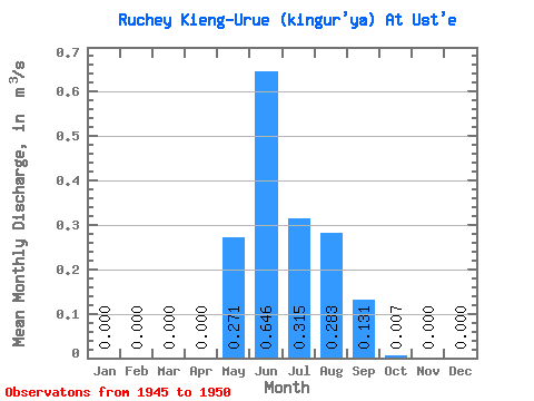
| Mean | 0.00 | 0.00 | 0.00 | 0.00 | 0.27 | 0.65 | 0.32 | 0.28 | 0.13 | 0.01 | 0.00 | 0.00 | 0.14 |
| Standard Deviation | 0.00 | 0.00 | 0.00 | 0.00 | 0.26 | 0.55 | 0.20 | 0.18 | 0.13 | 0.01 | 0.00 | 0.00 | 0.09 |
| Min | 0.00 | 0.00 | 0.00 | 0.00 | 0.00 | 0.08 | 0.12 | 0.05 | 0.03 | 0.00 | 0.00 | 0.00 | 0.04 |
| Max | 0.00 | 0.00 | 0.00 | 0.00 | 0.63 | 1.42 | 0.68 | 0.51 | 0.31 | 0.01 | 0.00 | 0.00 | 0.24 |
| Coefficient of Variation | 0.95 | 0.85 | 0.65 | 0.64 | 0.98 | 0.66 | 0.62 |
 Return to R-Arctic Net Home Page