|
|
|||||||||||||||||
| Point ID: 8031 | Downloads | Plots | Site Data | Code: 1038 |
|
|
|||||||||||||||||
| Download | |
|---|---|
| Site Descriptor Information | Site Time Series Data |
| Link to all available data | |
| View: | Time Series | All |
| Units: | mm |
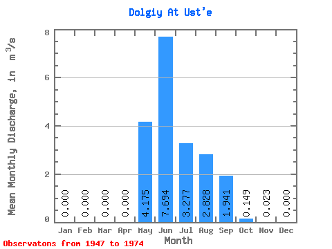
| Statistic | Jan | Feb | Mar | Apr | May | Jun | Jul | Aug | Sep | Oct | Nov | Dec | Annual |
|---|---|---|---|---|---|---|---|---|---|---|---|---|---|
| Mean | 0.00 | 0.00 | 0.00 | 0.00 | 4.17 | 7.69 | 3.28 | 2.83 | 1.94 | 0.15 | 0.02 | 0.00 | 1.67 |
| Standard Deviation | 0.00 | 0.00 | 0.00 | 0.00 | 2.95 | 5.57 | 2.50 | 1.94 | 1.46 | 0.17 | 0.05 | 0.00 | 0.55 |
| Min | 0.00 | 0.00 | 0.00 | 0.00 | 0.86 | 1.92 | 0.50 | 0.52 | 0.26 | 0.05 | 0.00 | 0.00 | 0.76 |
| Max | 0.00 | 0.00 | 0.00 | 0.00 | 14.00 | 23.30 | 9.25 | 8.78 | 5.73 | 0.96 | 0.21 | 0.00 | 2.91 |
| Coefficient of Variation | 0.71 | 0.72 | 0.76 | 0.69 | 0.75 | 1.12 | 2.17 | 3.88 | 0.33 |
 Return to R-Arctic Net Home Page